Conservation & Research
What are the leading causes of deforestation in coastal Ecuador?
Historically, cattle ranching is the leading cause of deforestation in coastal Ecuador, followed by slash-and-burn agriculture, mostly for corn cultivation. Monoculture plantations of palm oil trees and teak trees also play a significant role. Along the shoreline, mangrove forests have been cleared to make way for shrimp farms.
In general terms, the driver of deforestation in coastal Ecuador and throughout tropical Latin America is unsustainable agricultural expansion, which is primarily driven by the demand for meat and dairy. Cattle ranching, alone, causes 71% of deforestation in South America. In coastal Ecuador in particular, cattle are primarily raised to produce beef.
Sources:
Why is coastal Ecuador more deforested than the Amazon?
Prior to the 20th century, the vast majority of coastal Ecuador was blanketed with a diversity of tropical forests—including Chocó rainforest, premontane cloud forest, seasonal moist evergreen forest, tropical dry forest, and mangrove forests. Since then, it is estimated that 98% of its original forest has been lost.
The Amazon, in contrast, has lost 20% of its forest. It has been (partially) protected from deforestation by virtue of its relative inaccessibility.
Coastal Ecuador has suffered much higher rates of deforestation mostly because of its location and accessibility. Coastal Ecuador is sandwiched in between the relatively populous Andean highlands and the Pacific Ocean, both of which serve as entry points into the region. This paved the way for frontiersmen and agricultural expansion, which was accelerated by government subsidies that incentivized clearing forests for cattle ranching. Banana plantations, palm oil plantations, and now teak and balsa plantations followed suit. Much of Ecuador’s fruit production also comes from the coastal region.
What makes coastal Ecuador so ecologically diverse?
Short Answer: Coastal Ecuador is located at the nexus between some of the most powerful ecological forces on the planet: to the west is the Pacific Ocean, to the east is the Andes mountain range, to the north is the wettest forest on earth, and to the south is the driest desert on earth. As a result, Chocó rainforest, premontane cloud forest, seasonal moist evergreen forest, tropical dry forest, and mangrove forests all coincide in one fantastically biodiverse region.
Ocean currents, elevation, and latitude are what drive the variations in moisture levels in coastal Ecuador. In turn, moisture levels primarily drive variations in vegetation and wildlife.
Long Answer: The cold waters of the Humboldt ocean current are generated off the southern tip of South America and flow up along the coast of the continent, creating the world’s driest desert (the Atacama) in western Chile and Peru. And the Jama-Coaque Reserve is located in the very middle of all of this.
The warm waters of the El Niño ocean current, which is generated offshore of tropical Central America, create the wettest forests in the world, on the coast of Colombia.
Coastal Ecuador is located at the convergence of these two ocean currents and the ecological extremes which they create, accounting for the dramatic climatic variations that characterize the diverse ecology of the Pacific coast of Ecuador. Throughout the region, rainfall varies sharply, along both the north-to-south gradient and as a function of elevation. Average annual rainfall ranges from over 4,000 mm at the Colombian border to as little as 100 mm at the Peruvian border.
Even within the same latitude, there can be xeric (very dry) conditions along the shoreline and then pluvial (very wet) conditions as little as six kilometers inland along the peaks of the coastal mountains. Species characteristic of both of these extreme conditions can often be found cohabitating within the same stream valley.
The ocean also generates a fog layer that shrouds the peaks of the coastal mountains most of the year, creating cloud forests. At this elevation, much of the annual precipitation is generated in the form of fog drip (also called horizontal precipitation), in which fog condenses on plant foliage and then drips down onto the ground below. The cloud forest is wet and green every day of the year, even during the dry season. Conversely, the forests along the shores of the ocean are deciduous and lose their leaves during the dry season, in the same way that a temperate forest sheds its leaves in winter. In some parts of the Pacific Ecuadorian Forest, cloud forest and deciduous forest are separated by as little as four kilometers. Between these two local extremes lies a unique forest type called “seasonal moist evergreen forest.”
Not to mention the mangrove forests along the shoreline, although these have largely disappeared because of shrimp farming.
Do indigenous communities live in or around the Jama-Coaque Reserve?
Short Answer: No. The area is primarily populated by the descendants of 20th-century frontiersmen and colonists from other parts of Ecuador. What happened in the 1900s of coastal Ecuador is remarkably similar to the westward expansion that occurred in North America during the 1800s.
Long Answer: The pre-Colombian civilization that thrived in the region—named Jama-Coaque—was driven to extinction shortly after the arrival of European explorers in the 16th century, mostly due to disease. The region was largely depopulated during the 1700s and 1800s, after which it was re-populated with colonists from other parts of Ecuador.
The first modern-day settler of the nearby community of Camarones (adjacent to what is now the Jama-Coaque Reserve) is said to have arrived in 1901. Prior to this, the whole area was utterly wild and forested. In one century of time, much of that forest was lost. Most of the remaining forest is isolated to the upper stretches of the coastal mountain range, which is where the Jama-Coaque Reserve was born.
What are the ethics surrounding the purchase of land for conservation in coastal Ecuador?
In the sphere of ecological conservation and restoration, ethical questions are critically important—and not only for ethical reasons. A project that fails people will also face greater resistance and be harder to sustain over the long term. So it’s also a practical issue. This reality is at the core of our approach.
All of the lands that TMA has purchased to create the Jama-Coaque Reserve were previously uninhabited and owned by absentee landowners. Many of the previous landowners inherited the property from their parents, and some of them had never even set foot on the land. A fundamental criterion that we abide by, when deciding which forested properties to purchase and protect, is to not displace anyone.
The mere fact that nobody is currently occupying unprotected forest, and that the legal owners of the land aren’t actively caring for it, is a big part of the problem. The overexploitation of the rainforest in this particular region is a vivid illustration of the “tragedy of the commons.”
Forests that are unoccupied, unmanaged, and unmonitored become easy prey to illegal logging, illegal hunting, and “hit and run” agriculture, in which a parcel of forest is cleared, planted with corn for one season, and then abandoned. This cycle was gradually eroding this particular rainforest. In most parts of the region, the process was unchecked and resulted in total deforestation.
Total deforestation is not good for anyone—most of all the people who live downstream of the forest. The large swath of forest in the Jama-Coaque Reserve is the factory that creates the water in the river that sustains all of the communities downstream. If this river dries up, all of the communities that depend on it will collapse.
The only reason the river continues to run is that the headwaters of the river are densely forested. The fog and clouds that blow in from the ocean are “harvested” by the leaves of the trees. The water vapor condenses into water on the surface of the leaves, the water drips down into the forest, and slowly finds its way into the streams. There is not enough surface area on pasture grass to harvest enough water vapor to sustain this effect. If this forest is lost, the river dries up, and the community collapses. This is a socio-ecological fact.
Prior to the arrival of Europeans in the 1500s, there is reason to believe that these forests were sustainably managed by the Jama-Coaque civilization that thrived in the region. Or at the very least, the population density was low enough such that the ecological footprint was minimal.
This indigenous civilization was driven to extinction. The inhabitants that took their place were frontiersmen and colonists from other parts of Ecuador. What happened in the 1900s of coastal Ecuador is remarkably similar to the westward expansion that occurred in North America during the 1800s. The new inhabitants of this region lacked deep ancestral roots in this ecosystem, lacked ancestral knowledge, and their land-use decisions were strongly influenced by government subsidies that incentivized clearing forests to graze cattle and grow corn.
This is the reality of the situation in which this particular forest finds itself today. It is a deeply wounded ecosystem that is presently on the verge of expiring.
TMA’s job is twofold: 1) help stop the bleeding, and 2) to help restore it to health.
The most effective way to stop the bleeding is to protect as much of the existing rainforest as we can, so long as we don’t displace anyone in the process. The most effective way to protect the existing rainforest is to purchase it and actively protect it. That has been the principal focus of our work since 2007.
We are happy to report that this particular rainforest has stopped bleeding, thanks to the fact that it is being managed as a protected area. In this particular case, we believe this was the best approach. But now that the forest has stopped bleeding, the next task is to restore it to health. This is what our Community Reforestation Program is designed to do, but it’s designed in such a way that couples restoration with economic opportunities for people who live in the communities that surround the forest.
Whenever ecological conservation and/or restoration is pitted against people, there will inevitably be a loser. That is the nature of a zero-sum scenario. Everything we do is aimed at making conservation and restoration something that benefits people. We know that if we fail to do this, the entire project will fail. And that can’t happen.
This isn’t to say that we’re still learning. Our approach is constantly evolving. The north star that we use to orient our action is creating benefits from conservation and restoration for people in this area and beyond.
Reforestation & Carbon
What is Regenerative Agroforestry?
Regenerative agroforestry is an agricultural method that mimics natural forest ecosystems. Phrased differently: it’s a forest restoration method that employs a diversity of trees that also produce food and income for people.
The model of regenerative agroforestry that TMA uses for its Community Reforestation Program combines big native shade trees, fruit trees, heirloom cacao trees, and banana and plantain crops—all interplanted in the same parcel of land. Like a forest.
The big native shade trees perform the lion’s share of ecological services—including erosion control, watershed protection, sustaining the water cycle, soil fertility, habitat for wildlife, and removing CO2 from the atmosphere. The fruit trees, banana, plantain, and cacao provide local food security and a sustainable revenue stream for each family that participates.
How does the Community Reforestation Program work?
We’ve created a 2-minute animated video to answer this exact question. Check it out: Reversing Deforestation with Regenerative Agroforestry: How We Do It
What is the difference between reforestation and regenerative agroforestry?
In the strictest definition, conventional reforestation is the act of converting degraded land back into a forest that resembles its native vegetation. When this is done on uninhabited land that nobody depends on for food or income, this is usually a good idea.
But if the land is inhabited, or people do actively depend on it for food and income, conventional reforestation can be problematic. It pits the needs of nature against the needs of people. This is a conflict that usually doesn’t end well—for one side or the other. It is a zero-sum approach to ecological restoration.
Regenerative agroforestry is an agricultural method that mimics natural forest ecosystems. That’s one way to describe it. We like to phrase it differently. It’s a forest restoration method that employs a diversity of trees that also produce food and income for people. It is a win-win strategy for people and the planet.
What does “Payments for Ecosystem Services” (PES) mean?
Payments for Ecosystem Services (PES) are financial incentives offered to landowners in exchange for managing their land to provide some sort of ecological service—for example, planting trees that remove carbon from the atmosphere. That’s the most common example.
Another example is paying landowners to preserve forest at the headwaters of a river that provides drinking water to a large city downstream. In this case, the people downstream quantify the value of a clean and consistent water source, and then pay the people upstream to manage their land accordingly. Think of it as an economic solution to an ecological problem.
PES projects were pioneered by Costa Rica in the 1990s. Since then, they’ve become increasingly popular in the realm of conservation and reforestation. Technically, most carbon offset projects are also PES projects.
The world’s largest landscape restoration project is a PES program implemented by China, nicknamed “Grain for Green”. Cash incentives to 32 million households have triggered the restoration of over 28 million hectares over two decades. In the US, there are numerous ongoing PES programs aimed at watershed protection—ranging from Florida and San Antonio to Vermont and Oregon.
How much do we pay farmers to reforest degraded land, and why?
TMA uses PES payments to incentivize farmers to plant trees on degraded land.
TMA pays farmers $1,821 per acre over a 5-year period to reforest their own degraded land. This equates to $4,500 per hectare. This is a key feature of TMA’s Community Reforestation Program; it is the catalyst for change.
What is the cost structure of the Community Reforestation Program?
In total, it costs $3,025 per acre ($7,475 per hectare). Of this, 60% is paid directly to farmers in the form of cash payments over a period of five years—which is paid in monthly installments. This serves as bridge income for the first five years until the farmers’ cacao trees start generating an independent and sustainable revenue stream over the long term.
The remaining 40% is invested in seedlings & equipment (13%), training & technical assistance (10%), and monitoring & remote sensing technology (17%). The latter allows us to measure performance and verify results as efficiently as possible.
What is the difference between the Voluntary Carbon Market and the Mandatory Carbon Market?
Offsetting carbon emissions through the carbon market already plays a key role in the transition to a zero-carbon economy. The carbon market itself is split into two different markets: the mandatory (or “compliance”) market and the voluntary market.
Mandatory Carbon Market: Companies, governments, or other entities buy carbon allowances in order to comply with caps on the total amount of carbon dioxide they are allowed to emit—which is mandated by national laws.
Voluntary Carbon Market: Individuals, companies, governments, nonprofit organizations, universities, municipalities, and individuals purchase carbon offsets to mitigate their own greenhouse gas emissions from transportation, electricity use, and other sources. This is not mandated by any government: rather, it is voluntary.
The global management consulting firm, McKinsey & Company, predicts that “global demand for voluntary carbon credits could increase by a factor of 15 by 2030 and a factor of 100 by 2050.”
The Path Forward: The Mandatory Carbon Market and the Voluntary Carbon Market are both well-intentioned. But both models have lost some credibility in recent years because many projects overstate their benefits, don’t deliver the promised results, and lack transparency. TMA’s program is carefully designed to overcome each of those three pitfalls.
Direct Sponsorship Model: TMA does not “sell” carbon credits. Instead, we use the “direct sponsorship” model of carbon offsets. Individuals, businesses, and other institutions directly sponsor a specific family (or families) to reforest specific parcels of land. We monitor and verify every single reforestation parcel using a combination of site visits, digital monitoring technology, satellite imagery, and aerial photography from drones.
To learn more, check out our answer to the Frequently Asked Question: Does TMA “sell” carbon credits?
Does TMA “sell” carbon credits?
TMA does not “sell” carbon credits. Instead, we use the “direct sponsorship” model of carbon offsets. Individuals, businesses, and other institutions directly sponsor a specific family (or families) to reforest specific parcels of land. We monitor and verify every single reforestation parcel using a combination of site visits, digital monitoring technology, satellite imagery, and aerial photography from drones.
All of the above is shared directly with each sponsor. This way, sponsors can literally watch the forest grow over time. We also share parcel-by-parcel performance metrics and cost structure. We call this Absolute Transparency.
This unique approach is a response to what we believe to be flaws in the carbon offset market as it is known today. The standard model is beginning to lose credibility because many projects overstate their benefits, don’t deliver the promised results, and lack transparency. TMA’s Community Reforestation Program was carefully designed to overcome each of these three pitfalls.
Lastly, a general problem with the carbon offset market is the suspiciously low prices of most of the carbon credits that are offered. When it comes to bargain shopping for carbon offsets, our advice is this: buyer beware.
What is the price of carbon in our Community Reforestation Program?
The total cost to effectively reforest one hectare of land in our Community Reforestation Program is $7,475, which equates to $3,025 per acre. Each hectare is projected to achieve a net carbon benefit of 191.6 tons of CO2, or 77.5 tons of CO2 per acre. This equates to a total cost of $39.15 per ton of CO2. That is the true cost of carbon in the context of this particular project.
It’s important to note that the removal of carbon from the atmosphere is only one of several key benefits of this project. Other benefits include:
- Creates jobs and improves livelihoods in rural communities. Participating farmers increase their earnings by 4x.
- Improves local food security—a key factor for resilience during periods of economic adversity.
- Deforested lands are replaced with regenerative forests. Not only does this increase forest habitat, but it also reduces extractive pressure on the last remnants of native rainforest that still remain. Both of the above protect biodiversity in one of the most biodiverse and critically endangered ecosystems on earth.
How do we measure the carbon sequestration rate of our Community Reforestation Program?
We use two different approaches to calculate carbon stocks and CO2 sequestration of the regenerative agroforestry system used in our Community Reforestation Program.
- Site visits + state-of-the-art digital technology verification (RESTOR & FARM-TRACE)
- Reference studies from comparable restoration projects
Here’s a snapshot of the numbers:
- Net carbon benefit per hectare: 191.6 tons CO2
- Net carbon benefit per acre: 77.5 tons CO2
- Cost per ton of CO2: $39.15
How much does it cost to plant a tree?
The actual planting of a tree doesn’t cost much—but that, on its own, doesn’t really solve the problem. In our estimation, the actual planting of a tree represents maybe 2% of the overall work required to raise a tree to maturity. So the real question is: how much does it cost to raise a tree to maturity?
Our Community Reforestation Program costs $3,025, over a five-year period, to plant and raise over 300 trees in one acre of land (750 trees per hectare). If we divide the overall cost by the total number of trees, it comes out to about $10 per tree. Our overall survival rates typically exceed 90%, which includes a policy of replacing all trees that don’t survive the first five years.
How many trees are planted in each parcel?
On average, we plant at least 17 different species in each acre, totaling over 300 trees per acre. This includes:
- 8+ species of tall native shade trees
- 9+ species of fruit trees and food crops
| Required Species (By Category) | |
| Native Shade Trees | |
| Amarillo |
Centrolobium paraense
|
| Fernán Sánchez |
Triplaris cumingiana
|
| Guachapeli |
Albizia guachapele
|
| Laurel | Cordia alliodora |
| Pechiche | Vitex gigantea |
| Guayacán Negro |
Tabebuia chrysantha
|
| Cedro Calade | Ocotea sp. |
| Ceibo Gigante |
Ceibo trichistandra
|
| Fruit Trees | |
| Avocado |
Persea americana
|
| Jackfruit |
Artocarpus heterophyllus
|
| Breadfruit | Artocarpus altilis |
| Mango | Mangifera indica |
| Guaba | Inga spectabilis |
| Mandarin orange | Citrus reticulate |
| Main Cash Crops | |
| Cacao trees |
Theobroma cacao
|
| Plantain |
Musa × paradisiaca
|
| Banana | Musa acuminata |
How do we monitor the land to ensure that it is actually being reforested?
We monitor every single reforestation parcel three times per year using four overlapping methods, to ensure that nothing goes unnoticed.
- In-person site visits
- A state-of-the-art digital technology platform called FARM-TRACE
- High-resolution satellite images
- Aerial drone photographs of each parcel
We analyze and archive the satellite and aerial imagery for every single parcel. We also share these images with the people who sponsored the reforestation of that particular parcel. This is how sponsors can literally watch these forests grow over time.
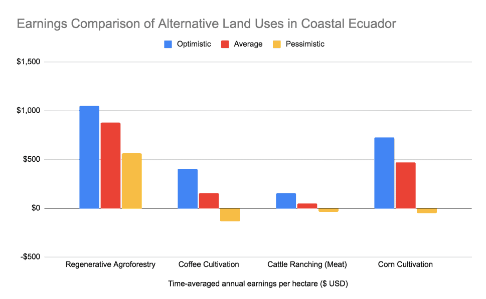
How much do farmers earn from regenerative agroforestry versus other activities like cattle ranching or corn farming?
To determine the opportunity cost for a farmer to participate in TMA’s Community Reforestation Program, we conducted a comprehensive comparative financial analysis of the most common land-uses available to farmers in this region. To do so, we compiled data from 24 different sources throughout the province—ranging from landowners, community agricultural cooperatives, government institutes and ministries, and our own experience as long-time agroforestry practitioners. The results are summarized below.
How much do farmers earn from regenerative agroforestry versus other activities like cattle ranching or corn farming?
Yes, and this is an important component of the Community Reforestation Program. The primary cash crop in this program is extremely high-quality heirloom cacao. In the absence of a “direct trade” relationship with a premium chocolate maker, most cacao farmers are forced to accept prices as low as $0.25 per pound of wet cacao from local intermediaries—even if their cacao is the highest quality. Low cacao prices represent a threat to the economic sustainability of this program.
This is where To’ak Chocolate comes in. To’ak is a for-profit social impact company based in Ecuador. It exclusively sources its chocolate from the highest-quality cacao in Ecuador and makes a conscious effort to pay farmers the highest cacao prices in the world—up to 820% above the Fair Trade price.
TMA and To’ak formed a strategic partnership to preserve and revive Ecuador’s most endangered heirloom cacao varieties. Together they created a micro-parcel to protect some of the last surviving Ancient Nacional cacao trees in Ecuador in the Jama-Coaque Reserve.
To’ak offers to buy cacao produced by the Community Reforestation Program at 3-9x the price of conventional cacao. This will significantly increase farmers’ earnings and ensure the long-term sustainability of regenerative agroforestry in this region.
The cacao growers in the Community Reforestation Program are under no obligation to sell their cacao to To’ak or any other buyer.
But cacao is not the only product that farmers will be able to commercialize. Banana, plantain, and even jackfruit all represent significant income potential. TMA is currently in the process of organizing supply-chain linkages that will connect farmers to lucrative markets.
Visiting the Reserve
Where is the Jama-Coaque Reserve located?
Find us on Google Maps, which uses the Spanish name: “Reserva Jama-Coaque.”
The Jama-Coaque Reserve (JCR) is located 12 km south of the equator line and 5 km inland from the shores of the Pacific ocean in Ecuador, about halfway between the mid-sized towns of Pedernales and Jama, and about 3 km inland from the small agricultural community of Camarones.
How do you pronounce “Jama-Coaque”?
You can download a recording of the proper pronunciation here.
Explanation:
The letter “J” in Spanish is pronounced like an “H” in English—that’s the key. So “Jama” is pronounced like “Hama.”
“Coaque” is more straightforward. It’s pronounced like “Koh-Ah-Kay.”
Altogether: “Hama Ko-Ah-Kay”
What does “Jama-Coaque” mean?
Jama-Coaque is the name of the ancient kingdom that thrived in these lands from 500 BC to 1531 AD. The Jama-Coaque civilization was driven to extinction shortly after the arrival of European explorers, mostly due to disease. The region was largely depopulated during the 1700s and 1800s, after which it was re-populated with colonists from other parts of Ecuador. The Jama-Coaque culture, famous for its unique style of artwork, left behind a vast amount of ceramic artifacts, some of which we’ve unearthed in the Jama-Coaque Reserve.
Do you invite volunteers or interns to come and help out at the Jama-Coaque Reserve?
We did for many years, but we eventually discontinued our volunteer and intern programs. We found that the amount of time and effort required to manage volunteers and interns exceeded the amount of productive work that most people were able to provide, given the circumstances. So we changed our approach.
In the years since, we’ve built a great team of people, from the nearby community of Camarones, who carry out important duties and fill key roles—ranging from field assistants to high-level managers. This new approach has greatly improved the management of the Jama-Coaque Reserve. It’s also an important source of jobs and income for people in the community.
Do you receive visitors at the Bamboo House?
The Bamboo House is primarily a research station. It is equipped to host:
- Researchers and scientists who are conducting research in the Jama-Coaque Reserve
- Student groups organized through partner institutions
- Loyal supporters and strategic partners of TMA
- TMA team members
We do not rent rooms on a nightly basis. We did experiment with this in the past, but we felt that the time and effort required to manage hospitality operations were detracting from our ability to manage our conservation, research, and agroforestry projects.
When is the best time to visit the Jama-Coaque Reserve?
Every single month of the year is beautiful in the Jama-Coaque Reserve. Nevertheless, there are seasonal variations.
Wet Season: The wet season begins in January, is the rainiest during February and March, gradually dissipates in April and May, and is usually finished by June. It doesn’t rain every day during the wet season. The wet season is characterized by bouts of rain (often at night) followed by bright sunny weather. The days are hot and tropical, but the temperature drops down to about 70° Fahrenheit (21° Celsius) every night. The land positively bursts with life, everything is green and the trails are muddy. A pair of $10 rubber boots (standard-issue, available for purchase in any small town in coastal Ecuador) are required for hiking.
Dry Season: The dry season starts in June and usually continues through the end of December. During these months, rainfall is extremely rare. At most, a misty drizzle. Paradoxically, the dry season is also more overcast than the wet season. The daytime temperature hovers in the mid-70s Fahrenheit (mid-20s Celsius), and the nighttime temperature drops to the high 60s Fahrenheit (20° Celsius). The rainforest is sustained by a nightly fog layer that descends upon the forest. The trails are usually dry enough to walk around in shoes—except up at the top of the mountain in the cloud forest, which is delightfully wet 365 days per year.
For casual visits, we recommend that people avoid February and March. The rains and muddy trails are less user-friendly. But if you’re a biologist—for example, a herpetologist researching frogs—February and March will be optimal. The timing of your visit depends on what you’re coming for.
Where is the nearest international airport?
We recommend flying into Quito, which is the capital city. The airport (UIO) is about 5.5 hours from JCR. The city of Guayaquil, which is just as populous as Ecuador, also has an international airport that is also roughly 5.5 hours from JCR. Quito is considered a nicer city to visit, relative to Guayaquil.
The regional airport of Manta is located 3 hours from JCR. There are also private airstrips much closer. Thus far, no visitors to JCR have ever put those airstrips to use, but they do exist.
What is the best way to get from Quito to the Jama-Coaque Reserve?
If you’re on a tight budget, you can take buses. It will be a long journey and require a few transfers, and then some walking, but it’s possible. This is how we used to do it during the old days (as in, like 2008). Technically, the entire trip can be done for about $12.
The far better option is to hire a trusted driver. If you’re interested in this option, let us know and we’ll make the arrangements. It costs $180 one way.
What should I pack when visiting Ecuador and the Jama-Coaque Reserve?
For Quito: pack the same clothes you’d pack for a city like San Francisco (i.e., cosmopolitan, warm-ish days but you’ll definitely need a jacket at night).
For the beach: pack the same clothes you’d pack for any warm-weather beach destination (t-shirts, shorts, swimsuits, sandals, hat for sun protection, sunglasses, sunblock).
For the Jama-Coaque Reserve
Clothing
- In the house at nighttime, you’ll want to wear any kind of pants and something with long sleeves (either a light sweater or simply a long-sleeve shirt). Also a pair of socks and shoes or something like Crocs.
- When you go romping through the rainforest: you’ll want a pair of hiking pants and a t-shirt, and expect both to get dirty. If you plan on staying for a few days (or more), you’ll need several t-shirts and perhaps an extra pair of pants.
- The most important thing is footwear. During the rainy season, we all wear these standard-issue rubber boots. We have over a dozen extra pairs at the house, which you’re welcome to use as long as you find a pair that fits. Otherwise, they cost about $10 at various stores in the nearby towns of Pedernales or Jama.
- During the dry season, you may be able to get away with wearing your own hiking boots—as long as you don’t mind if they get muddy.
- If you’re going to wear the standard-issue rubber boots (which we recommend), you’ll also want to wear a pair of heavy-duty socks, to protect against blisters.
- If it’s the peak rainy season, you could bring a rain poncho. Otherwise, that’s not necessary.
Accessories
- A hat, which will help protect your face from the sun.
- Insect repellant, if you want it.
- Headlamp—very useful. The house has solar-powered electricity but only downstairs.
- Non-disposable water bottle.
- If you’re finicky about towels, bring your own. Otherwise, we’ve got you covered.
What you DON’T need to bring
- Don’t bring water. The Bamboo House has the best water you’ll ever drink, naturally harvested from the land and properly filtered.
- No need to bring a sleeping bag or any type of bedding. We offer guests beds with mattresses, mosquito nets, sheets, blankets, and pillows.
- We do have towels. They won’t win any fashion contests, but they work. As noted above, you can also bring your own, if you prefer.
- No need to bring food, unless you have a very particular dietary requirement. If so, let us know ahead of time. We’re usually able to accommodate different dietary needs.
Do I need to get vaccinated or take anti-malarial pills when visiting coastal Ecuador?
No and no. There are no vaccines required to travel to Ecuador and malaria is not an issue in coastal Ecuador. If you also intend to travel into the Amazon rainforest—which is on the opposite side of the country, and a different ecosystem—you may be required to get a yellow fever vaccination or take anti-malaria pills. But no vaccines are required for coastal Ecuador. And we definitely do not recommend taking anti-malaria pills “just in case.” Nobody does that in coastal Ecuador.
Third Millennium Alliance (TMA)
When was TMA founded?
TMA was founded in 2007. This is the same year that TMA established the Jama-Coaque Reserve.
Is TMA a 501c3 nonprofit organization?
Yes. TMA is a registered nonprofit organization in both the United States and Ecuador. All donations made to TMA are tax-deductible in the United States. TMA’s U.S. federal tax identification number is 26-3982965.
Is TMA legally registered in the U.S. or Ecuador?
Both. TMA is a registered nonprofit organization in both the United States and Ecuador. All donations made to TMA are tax-deductible in the United States. TMA’s U.S. federal tax identification number is 26-3982965.
What is TMA’s mailing address?
36900 Bodily Avenue
Fremont, CA, 94536
U.S.A.
If you are asking because you wish to send a donation in the form of a check, please make the check payable to “Third Millennium Alliance”.
How do I donate?
Please go to our Support TMA page. It will provide you with several different ways to help protect and restore the most endangered rainforest on earth.
What is the relationship between TMA and To’ak Chocolate?
To’ak Chocolate is a for-profit social impact company based in Ecuador. It exclusively sources its chocolate from the highest-quality cacao in Ecuador and makes a conscious effort to pay farmers the highest cacao prices in the world—up to 820% above the Fair Trade price.
TMA and To’ak formed a strategic partnership to preserve and revive Ecuador’s most endangered heirloom cacao varieties. Together they created a micro-parcel to protect some of the last surviving Ancient Nacional cacao trees in Ecuador in the Jama-Coaque Reserve.
Today, TMA and To’ak are partnering with local farmers and distributing the progeny of these very same cacao trees within TMA’s Community Reforestation Program. Once these trees begin to produce, To’ak offers to buy this cacao at 3-9x the price of conventional cacao. This will significantly increase farmers’ earnings potential and helps ensure the long-term sustainability of regenerative agroforestry in this region.
The cacao growers in the Community Reforestation Program are under no obligation to sell their cacao to To’ak or any other buyer.
